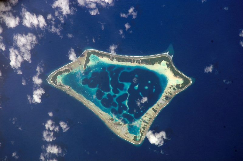
What country will disappear first…and the winner is….

Atafu Atholl, with 500+ residents, part of Tokelau, exemplifies hundreds of islands exposed to rising seas. [NASA image]
How do you define when an island has gone underwater – or for that matter, any community? Is it when the last square meter of land disappears? When the first house is fully submerged? The very last house? Half the houses? What if several houses remain intact, but there is no water to drink, or no functional port or airport? Like most contests for who is first, it depends on how the question is framed. Often, there can be multiple “winners” of such contests – though in this case, that’s not an appropriate term.
Typically cited as most vulnerable to disappear are Kiribati (pronounced Keer-ah-BAS), Tuvalu, Maldives, Marshall Islands, Seychelles, Tokelau, and Solomon Islands scattered across the Pacific and Indian Oceans. Their situations vary in terms of elevation, geologic structure, and how freshwater resources are impacted. Changing ocean currents could put one island underwater ahead of another that’s even an inch lower. Does it matter?
In the Atlantic, the iconic Bahamas with dozens of inhabited islands are home to almost 400,000 people. A study published by Columbia University, puts the Bahamas literally at the top of the list at risk from rising sea level globally. Eighty-eight percent of their population is in the danger zone, defined as being less than five feet above sea level. The fact that the Bahamas is at the number one position is very much a function of the format and structure of that particular study. Even when sea level is three meters higher (about 10 feet) considerable areas of New Providence (Nassau) as well as Grand Bahama, Eleuthera, etc. will still be well above water.
Bangladesh and Vietnam have a hundred times greater population at risk than the Bahamas, but a lower percentage of population exposed. Kiribati and the Maldives effectively have 100% exposure but did not meet other criteria of places in that survey. Like most polls and statistics, the headline ranking is largely a function of how the analysis is structured and the questions are worded. (As the saying goes, there are lies, damn lies, and statistics.)
Even on islands with high elevations such as Cuba, Dominica, the Virgin Islands, and Puerto Rico in the Caribbean, much of the development has occurred right down near sea level. Those islands with high elevation have an advantage, but will want to begin changing their building codes and development planning ASAP if they want to reap the benefits in the latter part of the century. It’s understandable that those tourist destinations do not want to portray themselves as vulnerable and jeopardize further investments. Nonetheless, the sooner they start the process of adaptation—by changing building codes, zoning, and infrastructure—the likelier they are to be resilient and have a viable future.
Rather than being fixated on who goes underwater first, it’s better to put the attention into how the millions of residents of thousands of low-lying islands can adapt to rising seas and more frequent flood events. In the longer term, those most vulnerable, those without large areas of higher ground, should begin planning for relocation. In addition to improving resiliency to flood events, and beginning to adapt to unstoppable rising seas, those concerned should also be encouraging the reduction of greenhouse gas emissions. The rise in greenhouse gases, particularly carbon dioxide, is the underlying force for the warming that ultimately is causing the ice sheets to melt and the sea to rise.
