Sea Level not the same everywhere; up to 300 foot variation.
One would think that sea level would be the same height everywhere, if we eliminated the waves and the high/low tide variation. We would be wrong; very wrong. I must admit that as I have researched my book about rising sea level, that was one of the most surprising things I came to understand. I knew there were some variations, but had no idea how great they were.
Let’s look at 3 causes of variation — one of which you likely know pretty well. Again, we will assume a “flat sea” without any waves, just to remove the distraction of varying wave heights, for the purpose of this insight.
We start with the rather familiar high and low tides because if we understand tide’s properly, the following VERY SURPRISING concept is much easier to explain.

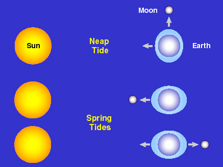
And as the illustration to the right shows, when the sun and moon are in alignment, the tidal bulge is greater, known as “spring tides.” As you likely know the tides vary in accord with lunar cycle. When the sun and moon are in alignment – the “new moon” the pull is greatest, and the tides are at their highest and lowest. When the sun and moon are at right angles, in terms of the Earth, the “neap tide”, tides are at a minimum, since the oceans are being pulled by opposing forces. (This is the simplified version; for a more detailed explanation, see Tides.)
The seond variation in sea level is the strange one. The Earth is not a sphere, or round ball. If anything it is more “pear-shaped” but even that is just a rough approximation. There are the mountains, the ocean depths, and massive deposits of iron and other heavy substances. All of these things make the planet not only bumpy and lumpy, they cause the MASS of the planet to vary greatly from place to place.
If we recall from the tides that water has mass, and masses attract, it stands to reason that more water will be attracted to those areas on the planet with greater relative mass, or density. Is there much variation from the ocean ‘highs’ to ‘lows’? I was stunned to learn that it was up to 300 feet difference (90 m).
And this will change over the next few centuries as the really MASSIVE ice sheets on Greenland and Antarctica melt, due to the warming. Those enormous weights of ice towering several miles high will largely redistribute globally over the ocean. (No need to panic, it will take hundreds of years, possibly thousands.)
In the process that will redistribute the mass of the planet, changing the way that the ocean is attracted to that mass, changing the relative height of the ocean. WHEW! It took me a moment to get my arms around that. (For a further explanation see a good article that appeared last year in SPIEGEL at http://www.spiegel.de/international/world/0,1518,732303,00.html
The third variation we will look at is really one of viewpoint perspective. Imagine, just for the sake of this illustration, that you were at the coast and had a vertical measuring stick to note the height of the sea. And imagine we eliminated all the waves and the tides, to simplify things. Let’s say that over the century you recorded that sea level rose by 3 feet (a meter roughly). But what if the land in the place you were at, was moving upward by a foot over the same century, or down for that matter. It would have to be considered to know how much the ocean height had changed.
In other words if it appears the ocean rises by 3 units over a period of time, but your viewing point rose by one unit, then the ocean rose by 4 units. I know this too can be confusing. And while it is hard to think of land moving up or down it happens all over the world. For example, in Yellowstone national park, the volcanic activity is causing the earth to bulge visibly upward. (Scientists believe it indicates another volcanic eruption is coming.)
New Orleans on the other hand is moving downwards due to three primary reasons. The soft silts from the Mississippi RIver literally compact over time. Also, the removal of ground water pumping from the upper layers, and huge petroleum deposits from deeper layers causes the crust to compact, lowering the elevations. This will worsen the impact of rising sea level.
Alaska presently has the opposite situation. It is UPLIFTING or rising in a rebound effect from the melting ice sheets since the last ice age and the melting of glaciers. The land is moving upward faster than sea level is rising, so the ocean appears to be going down in the present era. As the rate of sea level rise increases, it will overcome the uplift rate later this century, and Alaskans will also observe relative sea level rise on their shorelines. This distortion of perceived sea level rise is why I did my previous blog, giving a story in the AUSTRALIAN my stupid story of the week. They had headlined some research implying that sea level rise was slowing down. Nonsense as my other blog explains, “Why Sea Level will Rise for Centuries; ultimately 100 feet +.“
I should note that there are several other reasons for sea levels to vary in different places, but need to leave those for my forthcoming book. The point to takeaway is that sea level is much more complicated that anyone would suspect. If someone points out an apparent contradiction such as a declining sea level, that needs to be put in context.
Hopefully you have found this helpful. If so, please share it or leave a comment.
Thanks.
