
Florida is Not Going Underwater, at least not all of it
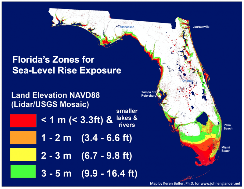
Florida Map w Elevation Zones to 5 meters
There is a widespread belief that Florida will be the first state to go underwater due to rising sea level. Even the fact-checked New York Times described Florida as “going beneath the waves.” However that is not at all correct. Vulnerability to rising sea level is hyper-local and cannot be generalized. As the four color coded elevation zones on this map show, Florida is far from flat. Even when sea level rises five meters ––approximately sixteen feet––the majority of the state will still be high and dry. Even on our current path of burning increasing amounts of fossil fuel, most aggressive estimates for sea-level rise put that a century or more into the future,
The perception that the State of Florida is just a few feet above sea level is simply wrong. There are of course some very important parts of the state that are three feet or less above sea level – approximately a meter. Most of greater Miami, the Florida Keys, and Fort Lauderdale are in that highly vulnerable zone. However, Orlando, the vacation mecca in the middle of the state is 82 feet (25 meters) above sea level and not at all vulnerable. Tallahassee, the capital, is more than 200 feet above sea level.
Florida does stand out as the state with the lowest high-elevation point – how’s that for a contradictory term. Florida’s high point is 345 feet above sea level, the lowest of all fifty states. Thus it will never go completely underwater, even if all the ice sheets and glaciers on the planet melt, since a total meltdown of all the ice sheets glaciers would raise sea level 212 feet (65 meters). That could take thousands of years, depending on how warm the planet gets. With Florida’s mean (average) elevation at 100 feet it is vulnerable, but the state will be around in some form, at least for centuries. In contrast, Delaware’s mean elevation is only 60 feet, so most of Delaware will go beneath the waves long before Florida.
Of course playing the game of who is first in this situation is pointless and unproductive. We could examine each of the two dozen U.S. coastal states and look at highly vulnerable areas to rising sea level and flooding. Every state on the Pacific, the Gulf of Mexico, and the East Coast has highly vulnerable low-lying areas, places you might not immediately think of, from Maine to Connecticut to the Carolinas, to the entire Gulf coast. The same for each of the almost two hundred coastal nations.
Rather than wondering who will submerge first, or most completely, our concern needs to be on how to slow the rising sea, by slowing the warming that is occurring due to the burning of fossil fuel. As long as the planet keeps warming, the ice sheets and glaciers on Antarctica and Greenland will keep melting, raising global sea level. We have passed the tipping point. The process cannot soon be stopped. So in addition to slowing the warming, we need design for greater resiliency to short-term flood events and begin adapting to slowly rising sea level.
“Broad brushing” a large area as being vulnerable to rising sea level is generally misleading and wrong. Assessing vulnerability to rising sea level needs to be done hyper-locally.