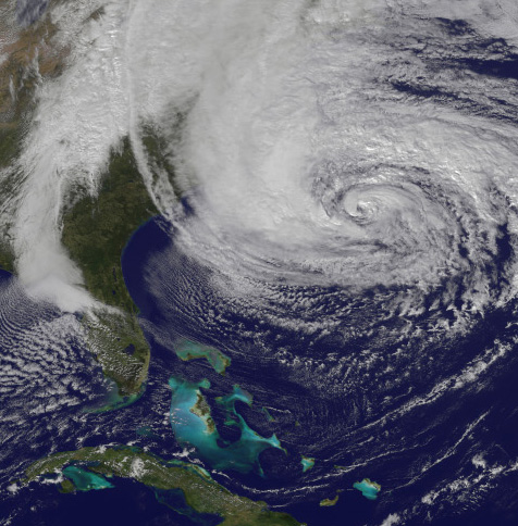
What if Sandy had been a real Hurricane?
 The term “Superstorm Sandy” irks some who think it should just be called a hurricane, rather than hyped into something special. Six months after the landmark event, it turns out that Superstorm may be exactly the right term, but perhaps not for the reason most assume.
NOAA – the National Oceanic and Atmospheric Administration – which encompasses the National Weather Service felt it was appropriate to do a retro analysis of the event and the communications related to it, to learn lessons for the future. That report, “Hurricane/Post-Tropical Cyclone Sandy, October 22-29, 2012” was recently published in May 2013, about six months after the disaster. At 66 pages, it is comprehensive. Without going into detail, I will give you two key points that strike me as worth noting:
First, a lot of confusion and misinformation in the critical days prior to impact at Atlantic City had to do with the fact that the predicted wind speed was just around the threshold for a hurricane. Technically hurricanes have minimum wind speeds of 74 mph (also 64 knots or 119 kmh).
Because many of the protocols for warnings and evacuations differ for a hurricane versus a tropical storm, there was a lot of focus on its forecast speed and what actions to take in terms of public notification. Would it be a hurricane or “just a storm”?
In hindsight, the weather service itself realizes that such a fine distinction was a distraction and the basis for mixed signals to the public as well as officials and those involved with emergency management.
The second related point that jumped out at me, was the finding that it is actually questionable whether Sandy was a hurricane when it made landfall. Most of us thought it was. The experts still are not exactly sure. It was borderline, having been a hurricane, but was slowing down and technically may not have been one at the time of landfall (technically identified as Brigantine, New Jersey).
At this point you are probably thinking the same thing as me: Who cares whether it was over the threshold? At 1,100 miles in diameter it was the largest Atlantic storm system ever recorded. Giving it a little more thought, I have a few other observations that may be worth sharing:
-
It is quite understandable that we have some categories or cutoffs as to when to evacuate people and take other extreme measures that affect people’s lives, property, and communities.
-
Yet it is easy to get caught up in our world of rules and categories and miss the real world staring us in the face.
-
In an era with more and more weather that is beyond the normal experience and pattern of recent decades (and centuries) we need to stay alert for truly unprecedented events, like this one.
-
It was the fact that Sandy was so wide that accounted for such an unusual storm surge. The width of more than a thousand miles more than made up for what it lacked in wind speed, with the huge umbrella of low pressure pulling an incredible bulge of seawater.
-
As I point out in my book, High Tide On Main Street, such a storm event will have maximum impact when it hits at abnormal high tide, and in certain locations where topographic features will amplify the storm surge. Both of those conditions occurred with Sandy.
-
As it was, Sandy was the second costliest hurricane in US history. What if it had been “a real hurricane” with even stronger winds? When will that event occur? Where?
-
Will we have learned anything from Sandy to be better prepared?
I found NOAA’s look back worthwhile. Perhaps you will find it helpful to share this with others now that we are well into the 2013 hurricane season. This is the early stage of the season. Sandy was a late season event. Also worth noting: hurricane seasons have been getting longer.
During times of change, we all need to stay observant.
If you found this interesting or useful, please share. To receive my occasional posts, please sign up on the home page. Names are kept confidential, not sold or bartered. No ads. With sign up, receive a free Special Report “10 Lessons from Superstorm Sandy.”
