
You Can Explore Boston Sea Level Rise And Flooding Scenarios With This City Map – WBUR
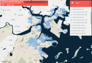 Article Synopsis – A recently released city tool allows users to see areas of climate concern in Boston with an interactive map. The tool allows users to layer various data sets onto the map, including sea level rise and flood risk, as well as vulnerable populations and areas of high temperatures. The data comes from the city’s extensive Climate Ready Boston report as well as local data from the Boston Harbor Flood Risk Model. To read the actual article click here.